Thursday, April 12, 2012

Clouds, Wind Pressure, and Fronts of the San Luis Valley


     Based on the sand composition of the Great Sand Dunes, it can be concluded that the sand originated mainly in the San Juan Mountains.  
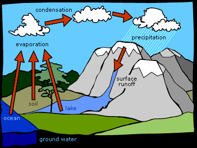
As explained in the last post, this is due to the process of weathering the San Juan Mountains.  The process of erosion (movement of weathered sediments) is what is responsible for the carrying of sand to the eastern boarder of the San Luis Valley were the active dune-filed lies.  Most of the time, this erosion process is fueled by wind currents which occur in the valley.
Picture showing the direction of wind in the San Luis Valley.

     One such wind current is the Alamosa Rose Wind.  This is a Southwesterly wind which North through the San Luis Valley until it reaches the base of the Sangre De Christo Mountains.  This predominant wind force (air pressure) is created through thermal variance in air cells in the San Luis Valley.  Since the valley floor is relatively flat and low in elevation (when compared to the mountains surrounding the valley) it can be concluded that the air in the valley is warmer than the air found nearer the mountains.  As the third law of geography states, wind always blows from high to low pressure.  Since warm air usually has higher pressure than cool air, the wind in the valley blows the sand towards the mountains where the elevation is higher thus resulting in cooler air masses.  This process can be thought of as a cyclone (when warm high pressure air flows to cooler low pressure air).  As the winds rise up the Sangre De Christo range, the sand falls out and becomes deposited at the base of the mountains.  The sand is deposited in this particular location in the valley because the wind exits the valley over the Medano, Mosca, and Music Passes (low spots at the peak of) the Sangre De Christo Mountain Range.  It is here where the winds funnel over the mountains.  If a map of wind currents was to be done at these passes, the isobars would be very close together.  This process is more noticeable during the spring months since the variance in temperature between the mountains and the valley is greater during this time.
Picture showing the lifting condensation level of clouds.

     As the warm air climbs the Sangre De Christo Mountains it becomes cooler and reaches its dew point this is when clouds form.  This is known as orographic lifting (when topographic features force air to rise).  As the moisture in the air cools it condenses on particulate matter in the atmosphere.  This does not occur until the air reaches the Lifting Condesation Level (at which the temperature is correct for dew (clouds) to form). 
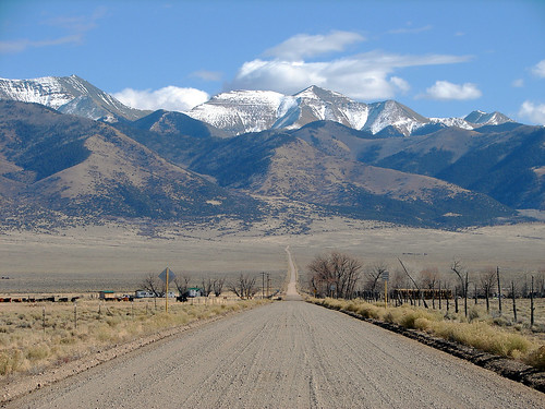
Diagram showing the rain-shadow effect.
 It is interesting that the San Luis Valley is located in the rain-shadow (leeward side) of the San Juan Mountains and receives 8 inches of precipitation a year.  However, the valley is also located on the windward side of the Sangre De Christo Mountains.  As the air rises up the mountains clouds can be seen forming at the peaks of the Sangre De Christo Mountains.  These clouds cannot proceed over the mountains until they release their water weight.

Interesting facts:  The sand dunes absorb lots of heat during the summer, and results in a surface temperature of about 140 degrees Fahrenheit
Picture of a fulgurite.

When lightning strikes the dunes, it produces Fulgurites.  These are columns of sand that have been melted together from the extreme heat of a lightning strike.   

Thursday, March 8, 2012

Weathering, Erosion, Hydrology, and Soils associated with The Great Sand Dunes

Weathering can be thought of as the breakdown (decaying) of rocks while erosion can be defined as the movement of weathered material.  This is the process in which massive boulders and bedrock gradually (over thousands and thousands of years) turn to fine grain sand.  This entire process of giant rocks turning into sand can be found at the Great Sand Dunes.  The process of erosion begins when the Sangre De Christo and the San Juan Mountains weather.  The weathered material is transported either into the San Luis valley or directly to the dunes by way of wind or water.  The mountains weather in a variety of different ways.  All of the ways these mountains erode can be classified as either physical or chemical weathering.  Physical weathering can be defined as the breakdown of rocks through a mechanical process. 

 
A diagram showing the effects of ice wedging (thermal-expansion).

     This type of weathering can include thermal-expansion.  Thermal expansion occurs when joints (cracks) in rocks are filled with water.  As the water freezes it expands and cracks the rock.  As the ice melts, the space left by the ice wedge is larger than it was before the process occurred.  This leaves a greater area to be filled with water the next time the process occurs thus causing the volume of water to expand even more.  As this process occurs multiple times high in the mountains the large rocks eventually break apart. Other examples of physical weathering that can occur near the sand dunes are root wedging, and crystallization wedging.  Both of which work in very similar ways to ice wedging except for the material doing the weathering is either a root or a crystal forming. 
     Chemical weathering can include acid rain or any other process that breaks down rocks through a chemical means. 
     After the rocks are weathered high in the mountains, the weathered material is carried into the San Luis Valley by an extensive system of rivers surrounding the dunes. 

 
A map showing the system of creeks surrounding the dunes.

     These rivers (creeks) include Little Medano Creek, Medano Creek, Castle Creek, Buck Creek, and Garden Creek.  All of these streams flow out of the Sangre De Christo Mountains and deposit small bits of weathered material at the base of the dunes.  As for the San Juan Mountains, the processes in which these mountains are weathered are similar to the process at work weathering the Sange De Christo Mountains.  The difference lies in the erosion of the weather material.  Since the San Juan Mountains are located across the San Luis Valley from the dunes, the weathered material from the San Juan Mountains is deposited in the valley.  Since the valley is flat and desert-like and the Mountains surrounding it are tall and often cold, there is wind always present.  This southwesterly wind is what accounts for the transport of sand from across the valley to the dune field.


A simple rendering of the Hydrologic cycle.

Part of the hydrologic cycle can also be observed at the sand dunes. As snow falls atop the Sangre De Christo and the San Juan Mountains, it melts and causes a spring time run-off.  When the glaciers melt, they feed the streams I mentioned before.  An interesting fact about Medano Creek is that part of it is only visible during the time of year at which the snow melts.  After this, there is not enough water to saturate (fill) the phreatic zone, and the creek in turn goes underground where the rest of the river is year round.  The dune field has lots of pore space which can absorb lots of water.  Since the San Luis Valley is desert-like, much of the water evaporates and returns to the ground as rain, or flows into larger rivers and heads towards lowland bodies of water.      

     There are many soils that can be found surrounding the Great Sand Dunes.  For example there is lots of sand which can be found due to the shape of the valley and the processes of weathering and erosion.  There can be found soils with organic compounds because although the San Luis Valley is a desert the bases of the Sangre De Christo and San Juan Mountains are covered with indigenous plant life such as Pinon Trees.
a video showing the awesome surges that occur in Medano Creek.  As sand erodes and flows in the river its builds tiny dams that hold water until they break causing these surges! Can only be seen in very,very few places on earth.

Monday, February 13, 2012

Volcanism/Plate Tectonic Activity around The Great Sand Dunes

As mentioned before, the geographic region surrounding The Great Sand Dunes is the result of many geologic processes occurring over long periods of time.  For this blog post, volcanism and plate tectonic activity will be addressed as they pertain to the creation of this one of a kind landscape. 

The San Juan Mountains (From San Luis Valley)

To begin, I would like to mention that the San Juan mountain range was created due to volcanic activity that took place around 30 million years ago.  It is believed that this mountain range’s life began when the eruption of La Garita Caldera occurred.  This eruption left a massive caldera.  After years of volcanic activity (lava flows and tuffs) the San Juan Mountains were born.  The type of volcano that erupted to create the San Juan Mountains can be referred to as a strato-volcano.  These volcanoes are extremely explosive due to their composition.  These volcanoes are unlike cinder cone, and shield volcanoes in that they often have more than one volcanic vent, and the mountains they create are often steep and jagged.  Forms that are associated with the process of strato-volcanoes erupting are, lava flows (which can be found today in the San Luis Valley), Nuee Ardente (Hot, avalanche-like, cloud of ash), and different pyroclastics (such as bombs and tephra which can still be found in the San Luis Valley).  Although the volcanoes have not erupted for thousands of years, there is evidence of volcanic activity that can still be found in the San Luis Valley.  This evidence comes in the form of geothermal energy created by many hot springs located in the area.    


This image shows faulting in the San Luis Valley (Alamosa Horst and Monte Vista/Baca Grabens)

The San Luis Valley was created through a diverging plate boundary also known as a rift zone.  35 million years ago the Rio Grande Rift became active. This plate divergence runs from Leadville, Colorado to El Paso, Texas.  As the rift moved, it created two low areas called the Monte Vista Graben (West) and the Baca Graben (East).  A raised area, central to these Grabens is called the Alamosa Horst.  Also due to this rift zone, the Sangre de Christo Mountain Range was uplifted, as it makes up the eastern boundary of the Rio Grande Rift.   This rift zone is only subject to minor tremors and is not expected to make large movements.

Aerial View of some Alluvial Fans
An interesting fact about the San Luis Valley I came upon was that if the Valley was excavated, the bedrock underneath it would be located about four miles below sea level.  The reason the valley is not this deep today is because as the Sangre De Christo and San Juan Mountains eroded and filled the valley with sediment.  This is an example of Alluvial fans seeing as how many rivers (ancient Arkansas and Rio Grande) and streams flow out of the mountains and into the San Luis Valley carrying sediments with them.

Monday, January 23, 2012

Introduction Post


     When asked to choose a geographic location to study and explain for the remainder of the semester, I immediately began to think of locations that have diverse geographic systems.  This was to ensure that I would be able to explain the many geographic topics that we will be discussing throughout the course of this semester with one landscape.  I also knew I wanted to choose a location that I have visited and wished to learn more about.  With this in mind, I decided to choose the Great Sand Dunes National Park, complete with massive mountain ranges, a rift vally, a desert-like atmosphere, and sand dunes it begs the question of how each system works in harmony with one another to create the landscape seen today.  Over the weeks to come my goal is to explain this question.  As can be noticed by the image posted above, this area is rich in many different geographic features which can be studied to explain the rare and beautiful creation of this diverse landscape.  An example of this is the Sangre de Christo mountains which form the magnificent backdrop for the dunes.  This mountain range along with many other geographic features play significant roles in the creation of the dunes as will be explained in posts to come.